Upper Arlington 🖤 Home Keepsake

Celebrate all of Upper Arlington with this colorful map depicting our city’s physical growth. Land annexations have increased our city’s size every decade since we became a village in 1918.
Measuring 4” x 2.5”, the keepsake features an acrylic front and a mirrored back. Also included with each keepsake are:
A card with the map’s legend and a link to this historical information.
Four miniature gold hearts to personalize the map by noting your favorite UA places.
This image, courtesy of the City of Upper Arlington, made its first public appearance on UA’s History Walk at Northam Park on July 4, 2018 as part of our city’s centennial celebration. The panel from the Walk appears below. The map legend describes the approximate population of Upper Arlington at that time and a significant community event during the decade:

Fun Facts:
Note that it was during the 1960s when Scioto Country Club (SE corner of Riverside Drive and Lane Avenue) was annexed into Upper Arlington. The official annexation date is October 14, 1968; prior to that, the Club had remained part of Perry Township. A June 24, 1968 Columbus Dispatch article (p. 19A) reported that, “club secretary Gerald H. Galbreath Jr. [stated that] the club’s board of trustees had voted in favor of being annexed to the suburban city.” What Scioto Country Club’s website states is definitely true, however, that “Scioto Country Club from its inception has always been an important part of the history of Upper Arlington.”
Wyandot Park along Riverside Drive was one of the small annexations made in the 1970s. In the early 1900s, the Columbus City Council donated these grounds to be the final resting place of Bill Moose, referring to the site as ‘Wyandot Hill.’ Bill Moose was locally known as the last full-blooded Wyandot Indian in this region. He passed away in 1937, and an estimated 10,000 people attended his viewing days and funeral proceedings. See more here.
The actual dates of annexations can be found on this map, thanks to the Upper Arlington Public Library’s UA Archives site. (Click on the diagonal arrow in the upper right of the image to expand.) Can you find what specific day your neighborhood became part of Upper Arlington?
a historical look at 1913 - one hundred and ten years ago
King Thompson and his brother, Ben, both in their mid-30’s in 1913, have an idea. The brothers had done smaller real estate development east and north of OSU, but they were inspired by the “Country Club District” in Kansas City (started in 1905) – a large planned community outside of the metropolitan area – and wanted to do the same in Columbus.
James Turrell Miller owned 1,000 acres of land we are standing on in 1913. It appealed to the Thompsons as a residential site because of:
its location on high ground,
its proximity to both downtown Columbus and The Ohio State University campus, and
its position upwind from the larger city.
A mutual friend arranged a meeting between the Thompsons and Miller on Christmas Eve 1913. It was then and there that they sealed the deal on the purchase of 840 acres of the "most suitable, most convenient and the most beautiful rolling, partly wooded Ohio farmland.”
The land was subdivided into 2500 lots and in 1914 public sales began for properties in “Upper Arlington.” See the 1914 sales brochure here.
a historical look at 1883 - one hundred and forty years ago
We have a detailed map of Perry Township from 1883, of which today’s Upper Arlington encompasses the southern half pictured below:
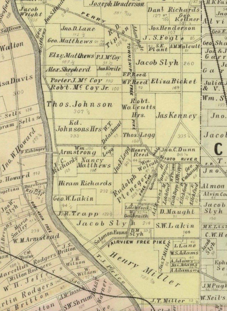
Our pioneer families owned the land at the time, with Upper Arlington’s origins thirty years in the future. Items to note include:
Today’s Lane Avenue is called Fairview Free Pike. Can you find other “free pikes” on the map? These were main thoroughfares that — unlike “pikes,” which were outfitted with long timbers to stop traffic and collect tolls — were free to travel.
Henry Miller, the large landowner in the most southern portion of Perry Township, was James T. Miller’s father. James T. Miller sold the Thompson brothers the land to being the Upper Arlington development and also served as our village’s first mayor. Watch a video about the Miller family here. (min 2:10-8:45)
Pleasant Litchford, the formerly enslaved person who purchased 227 acres in this area between 1833-1849, died in 1879. One can see on this map that his children now own the land in 1883 near today’s Tremont Elementary School (A. Litchford) and northwest of today’s Ridgeview and North Star roads. The rectangle noted as “Cath Depp” is now the UAHS property. For more detailed research findings about how property came to be owned by the Schools, click here.